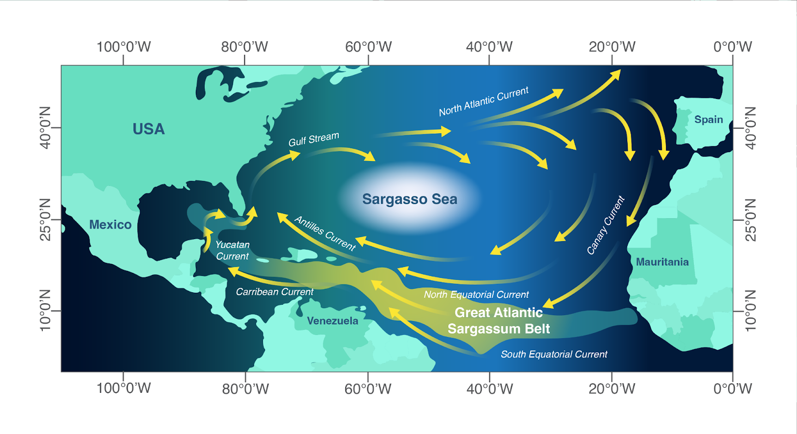
The Great Sargassum Belt was probably originally seeded by the Sargasso Sea. What seems to have happened is a slight shift in 2009/2010, in a weather (particularly air pressure) system that stretches between Iceland and the Azores called the North Atlantic Oscillation. This wobble (which could be attributed to climate change) led to some Sargassum being carried over to the coasts of Spain, Portugal and Morocco. From there it was carried by currents along the coast of west Africa where it was then picked up by the North Equatorial current1
At the same time, changes in land use - particularly deforestation and the associated increase in agriculture - and lack of water treatment has led to large flows of nutrients into the tropical Atlantic via the Amazon, Congo and Orinoco rivers. Sargassum that had survived its long pan-Atlantic trip, bloomed as it was carried into these excessively nutrient rich coastal waters12.
This bloom then started to hit the coasts of the Caribbean Sea and then as it was carried into the Gulf of Mexico, it met more nutrient rich waters and continued to bloom. This process has continued since 2011, when the great Sargassum belt was established in the northern equatorial Atlantic34.
This Sargassum belt is distinct from the Sargasso Sea Sargassum, to put it simply they are composed of different morphological types of Sargassum4. The Sargassum belt has been found to possess lower biodiversity than the Sargasso Sea4 and is dominated by highly nutrient efficient organisms.
Up to 100 million tonnes is growing each year, enormous amounts of it making landfall and causing devastation throughout the region. From the West Coast of Africa, throughout the Caribbean and Central America, coral reefs, mangroves, beaches, marine animals and humans are being poisoned by dense influxes of Sargassum from the Great Sargassum Belt each year.
-
What nutrient sources support anomalous growth and the recent Sargassum mass stranding on Caribbean beaches? A review (Marine Pollution Bulletin) ↩ ↩2
-
Satellite images suggest a new Sargassum source region in 2011 (Remote Sensing Letters) ↩
-
Mapping and quantifying Sargassum distribution and coverage in the Central West Atlantic using MODIS observations (Remote Sensing of Environment) ↩
-
Recent Sargassum inundation events in the caribbean: Shipboard observations reveal dominance of a previously rare form (Oceanography) ↩ ↩2 ↩3